Indian Space Research Organisation
Coordinates: 12°58′0″N 77°34′0″E
ISRO logo |
|
| Established | August 15, 1969 |
|---|---|
| Headquarters | Bangalore, India |
| Primary spaceport | Satish Dhawan Space Centre |
| Administrator | K. Radhakrishnan (Chairman) |
| Budget | |
| Website | www.isro.org |
ISRO’s first satellite, Aryabhata, was launched by the Soviet Union in 1975. Rohini, the first satellite to be placed in orbit by an Indian-made launch vehicle (the Satellite Launch Vehicle 3) was launched in 1980. ISRO subsequently developed two other rockets: the Polar Satellite Launch Vehicle for putting satellites into polar orbit and the Geostationary Space Launch Vehicle for placing satellites into geostationary orbit. These rockets have launched communications satellites, Earth-observation satellites, and, in 2008, Chandrayaan-1, India’s first mission to the Moon. ISRO plans to put two astronauts into orbit in 2015.
Over the years, ISRO has conducted a variety of operations for both Indian and foreign clients. ISRO's satellite launch capability is mostly provided by indigenous launch vehicles and launch sites. In 2008, ISRO successfully launched its first lunar probe, Chandrayaan-1, while future plans include indigenous development of GSLV, manned space missions, further lunar exploration, and interplanetary probes. ISRO has several field installations as assets, and cooperates with the international community as a part of several bilateral and multilateral agreements.
Contents
|
Formative years
Government support became visible by 1950 when the Department of Atomic Energy was founded with Homi Bhabha as secretary.The Department of Atomic Energy provided funding for space research throughout India.Tests on the Earth's magnetic field—studied in India since the establishment of the observatory at Colaba in 1823—and aspects of meteorology continued to yield valuable information and in 1954, Uttar Pradesh state observatory was established at the foothills of the Himalayas.The Rangpur Observatory was set up in 1957 at Osmania University, Hyderabad. Both these facilities enjoyed the technical support and scientific cooperation of the United States of America.Space research was further encouraged by the technically inclined prime minister of India—Jawaharlal Nehru.In 1957, the Soviet Union successfully launched Sputnik and opened up possibilities for the rest of the world to conduct a space launch. The Indian National Committee for Space Research (INCOSPAR) was found in 1962 with Vikram Sarabhai as its chairman.
Goals and objectives
The prime objective of ISRO is to develop space technology and its application to various national tasks.The Indian space program was driven by the vision of Dr Vikram Sarabhai, considered the father of Indian Space Programme.As stated by him:| “ | There are some who question the relevance of space activities in a developing nation. To us, there is no ambiguity of purpose. We do not have the fantasy of competing with the economically advanced nations in the exploration of the moon or the planets or manned space-flight. But we are convinced that if we are to play a meaningful role nationally, and in the community of nations, we must be second to none in the application of advanced technologies to the real problems of man and society. | ” |
| “ | Many individuals with myopic vision questioned the relevance of space activities in a newly independent nation, which was finding it difficult to feed its population. Their vision was clear if Indians were to play meaningful role in the community of nations, they must be second to none in the application of advanced technologies to their real-life problems. They had no intention of using it as a means of displaying our might. | ” |
Launch vehicle fleet

Satellite Launch Vehicle (SLV)
Main article: Satellite Launch Vehicle
-
- Status: Decommissioned
Augmented Satellite Launch Vehicle (ASLV)
Main article: ASLV
-
- Status: Decommissioned
Polar Satellite Launch Vehicle (PSLV)
Main article: PSLV
-
- Status: Active
On July 15th, 2011 the PSLV flew its 18th consecutive successful mission orbiting satellites. Its only failure in 19 flights was its maiden voyage in September 1993, providing the rocket with a 94 percent success rate.
Geosynchronous Satellite Launch Vehicle (GSLV)
Main article: GSLV
-
- Status: Active
In a setback for ISRO, the latest attempt to launch the GSLV, GSLV-F06 carrying GSAT-5P, failed on 25 December 2010. The initial evaluation implies that loss of control for the strap-on boosters caused the rocket to veer from its intended flight path, forcing a programmed detonation. Sixty-four seconds into the first stage of flight, the rocket began to break up due to the acute angle of attack. The body housing the 3rd stage, the cryogenic stage, incurred structural damage, forcing the range safety team to initiate a programmed detonation of the rocket.
Geosynchronous Satellite Launch Vehicle Mark-III (GSLV III)
Main article: GSLV III
-
- Status: In Development
Earth observation and communication satellites
The INSAT series
Main article: Indian National Satellite System
INSAT (Indian National Satellite System) is a series of multipurpose
geostationary satellites launched by ISRO to satisfy the
telecommunications, broadcasting, meteorology and search-and-rescue
needs of India. Commissioned in 1983, INSAT is the largest domestic
communication system in the Asia-Pacific Region. It is a joint venture
of the Department of Space, Department of Telecommunications, India Meteorological Department, All India Radio and Doordarshan. The overall coordination and management of INSAT system rests with the Secretary-level INSAT Coordination Committee.The IRS series
Main article: Indian Remote Sensing satellite
Indian Remote Sensing satellites (IRS) are a series of earth
observation satellites, built, launched and maintained by ISRO. The IRS
series provides remote sensing services to the country. The Indian
Remote Sensing Satellite system is the largest constellation of remote
sensing satellites for civilian use in operation today in the world. All
the satellites are placed in polar sun-synchronous orbit
and provide data in a variety of spatial, spectral and temporal
resolutions to enable several programs to be undertaken relevant to
national development. The initial versions are composed of the 1
(A,B,C,D) nomenclature. The later versions are named based on their area
of application including OceanSat, CartoSat, ResourceSat.Other satellites
ISRO has also launched a set of experimental geostationary satellites known as the GSAT series. Kalpana-1, ISRO's first dedicated meteorological satellite,was launched by the Polar Satellite Launch Vehicle on 12 September 2002.The satellite was originally known as MetSat-1.In February 2003 it was renamed to Kalpana-1 by the then Indian Prime Minister Atal Bihari Vajpayee in memory of Kalpana Chawla – a NASA astronaut of Indian origin who perished in Space Shuttle Columbia.Extraterrestrial exploration
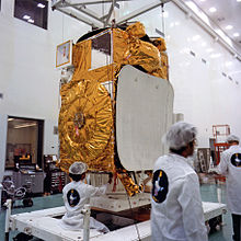
India's first mission beyond Earth's orbit was Chandrayaan-1, a lunar spacecraft which successfully entered the lunar orbit on 8 November 2008. ISRO plans to follow up Chandrayaan-1 with Chandrayaan-2 and unmanned missions to Mars and Near-Earth objects such as asteroids and comets.Lunar exploration
Main article: Chandrayaan-1
Chandrayaan-1 (Sanskrit: चंद्रयान-१) is India's first mission to the
moon. The unmanned lunar exploration mission includes a lunar orbiter
and an impactor called the Moon Impact Probe. India launched the spacecraft using a modified version of the PSLV is C11 on 22 October 2008 from Satish Dhawan Space Centre,
Sriharikota. The vehicle was successfully inserted into lunar orbit on 8
November 2008. It carries high-resolution remote sensing equipment for
visible, near infrared, and soft and hard X-ray frequencies. Over its
two-year operational period, it is intended to survey the lunar surface
to produce a complete map of its chemical characteristics and
3-dimensional topography. The polar regions are of special interest, as
they might contain ice. The lunar mission carries five ISRO payloads and six payloads from other international space agencies including NASA, ESA, and the Bulgarian Aerospace Agency, which were carried free of cost. The Chandrayaan-1 became the first lunar mission to discover existence of water on the moon.Planetary exploration
The Indian Space Research Organisation had begun preparations for a mission to Mars and had received seed money ofHuman spaceflight program

Main article: Indian human spaceflight program
The Indian Space Research Organization has been sanctioned a budget of Technology demonstration
The Space Capsule Recovery Experiment (SCRE or more commonly SRE or SRE-1)s an experimental Indian spacecraft which was launched using the PSLV C7 rocket, along with three other satellites. It remained in orbit for 12 days before re-entering the Earth's atmosphere and splashing down into the Bay of Bengal.The SRE-1 was designed to demonstrate the capability to recover an orbiting space capsule, and the technology for performing experiments in the microgravity conditions of an orbiting platform. It was also intended to test thermal protection, navigation, guidance, control, deceleration and flotation systems, as well as study hypersonic aero-thermodynamics, management of communication blackouts, and recovery operations.
ISRO also plans to launch SRE-2 and SRE-3 in the near future to test advanced re-entry technology for future manned missions.
Astronaut training and other facilities
ISRO will set up an astronaut training centre in Bangalore by 2012 to prepare personnel for flights on board the crewed vehicle. The centre will use water simulation to train the selected astronauts in rescue and recovery operations and survival in zero gravity, and will undertake studies of the radiation environment of space.ISRO will build centrifuges to prepare astronauts for the acceleration phase of the mission. It also plans to build a new Launch pad to meet the target of launching a manned space mission by 2015. This would be the third launchpad at the Satish Dhawan Space Centre, Sriharikota.
Development of crew vehicle
Main article: ISRO Orbital Vehicle
The Indian Space Research Organisation (ISRO) is working towards a
maiden manned Indian space mission vehicle that can carry three
astronauts for seven days in a near earth orbit. The Indian manned
spacecraft temporarily named as Orbital Vehicle intend to be the basis of indigenous Indian human spaceflight program.The capsule will be designed to carry three people, and a planned upgraded version will be equipped with a rendezvous and docking capability. In its maiden manned mission, ISRO's largely autonomous 3-ton capsule will orbit the Earth at 248 miles (400 km) in altitude for up to seven days with a two-person crew on board. The crew vehicle would launch atop of ISRO's GSLV Mk II, currently under development. The GSLV Mk II features an indigenously developed cryogenic upper-stage engine.The first test of the cryogenic engine, held on 15 April 2010, failed as the cryogenic phase did not perform as expected and rocket deviated from the planned trajectory. A future launch has been scheduled for 2011. If successful then ISRO will become the sixth entity, after United States, Russia, China, Japan and Europe, to develop this technology.
Planetary sciences and astronomy
India's space era dawned when the first two-stage sounding rocket was launched from Thumba in 1963. Even before this, noteworthy contributions were made by the Indian scientists in the following areas of space science research:- Cosmic rays and high energy astronomy using both ground based as well as balloon borne experiments/studies such as neutron/meson monitors, Geiger Muller particle detectors/counters etc.
- Ionospheric research using ground based radio propagation techniques such as ionosonde, VLF/HF/VHF radio probing, a chain of magnetometer stations etc.
- Upper atmospheric research using ground based optical techniques such as Dobson spectrometers for measurement of total ozone content, air glow photometers etc.
- Indian astronomers have been carrying out major investigations using a number of ground based optical and radio telescopes with varying sophistication.
There is a national balloon launching facility at Hyderabad jointly supported by TIFR and ISRO. This facility has been extensively used for carrying out research in high energy (i.e., X- and gamma ray) astronomy, IR astronomy, middle atmospheric trace constituents including CFCs & aerosols, ionisation, electric conductivity and electric fields.
The flux of secondary particles and X-ray and gamma-rays of atmospheric origin produced by the interaction of the cosmic rays is very low. This low background, in the presence of which one has to detect the feeble signal from cosmic sources is a major advantage in conducting hard X-ray observations from India. The second advantage is that many bright sources like Cyg X-1, Crab Nebula, Scorpius X-1 and Galactic Centre sources are observable from Hyderabad due to their favourable declination. With these considerations, an X-ray astronomy group was formed at TIFR in 1967 and development of an instrument with an orientable X-ray telescope for hard X-ray observations was undertaken. The first balloon flight with the new instrument was made on 28 April 1968 in which observations of Scorpius X-1 were successfully carried out. In a succession of balloon flights made with this instrument between 1968 and 1974 a number of binary X-ray sources including Scorpius X-1, Cyg X-1, Her X-1 etc. and the diffuse cosmic X-ray background were studied. Many new and astrophysically important results were obtained from these observations.
One of most important achievements of ISRO in this field was the discovery of three species of bacteria in the upper stratosphere at an altitude of between 20–40 km. The bacteria, highly resistant to ultra-violet radiation, are not found elsewhere on Earth, leading to speculation on whether they are extraterrestrial in origin. These three bacteria can be considered to be extremophiles. Until then, the upper stratosphere was believed to be inhospitable because of the high doses of ultra-violet radiation. The bacteria were named as Bacillus isronensis in recognition of ISRO's contribution in the balloon experiments, which led to its discovery, Bacillus aryabhata after India's celebrated ancient astronomer Aryabhata and Janibacter Hoylei after the distinguished astrophysicist Fred Hoyle.
Facilities
ISRO's headquarters is located at Antariksh Bhavan in Bangalore.Research facilities
| Facility | Location | Description |
|---|---|---|
| Physical Research Laboratory | Ahmedabad | Solar planetary physics, infrared astronomy, geo-cosmo physics, plasma physics, astrophysics, archaeology, and hydrology are some of the branches of study at this institute.An observatory at Udaipur also falls under the control of this institution. |
| Semi-Conductor Laboratory | Chandigarh | Research & Development in the field of semiconductor technology, micro-electromechanical systems and process technologies relating to semiconductor processing. |
| National Atmospheric Research Laboratory | Chittoor | The NARL carries out fundamental and applied research in Atmospheric and Space Sciences. |
| Raman Research Institute (RRI) | Bangalore | RRI carries out research in selected areas of physics, such as astrophysics and astronomy. |
| Space Applications Centre | Ahmedabad | The SAC deals with the various aspects of practical use of space technology.Among the fields of research at the SAC are geodesy, satellite based telecommunications, surveying, remote sensing, meteorology, environment monitoring etc. The SEC additionally operates the Delhi Earth Station. |
| North Eastern-Space Applications Center | Shillong | Providing developmental support to North East by undertaking specific application projects using remote sensing, GIS, satellite communication and conducting space science research. |
Test facilities
| Facility | Location | Description |
|---|---|---|
| Liquid Propulsion Systems Centre | Bangalore, Thiruvananthapuram, and Nagercoil | The LPSC handles testing and implementation of liquid propulsion control packages and helps develop engines for launch vehicles and satellites.The testing is largely conducted at Mahendragiri.The LPSC also constructs precision transducers |
Construction and launch facilities
| Facility | Location | Description |
|---|---|---|
| ISRO Satellite Centre | Bangalore | The venue of eight successful spacecraft projects is also one of the main satellite technology bases of ISRO. The facility serves as a venue for implementing indigenous spacecraft in India.The satellites Ayrabhata, Bhaskara, APPLE, and IRS-1A were constructed at this site, and the IRS and INSAT satellite series are presently under development here. |
| Laboratory for Electro-Optics Systms-LEOS | Bangalore | The Unit of ISRO responsible for the development of attitude sensors for all satellites. The high precision optics for all cameras and payloads in all ISRO satellites including Chandrayaan-1 are developed at this laboratory. Located at Peenya Industrial Estate, Bangalore. |
| Satish Dhawan Space Centre | Sriharikota | With multiple sub-sites the Sriharikota island facility acts as a launching site for India's satellites.The Sriharikota facility is also the main launch base for India's sounding rockets.The centre is also home to India's largest Solid Propellant Space Booster Plant (SPROB) and houses the Static Test and Evaluation Complex (STEX).[ |
| Vikram Sarabhai Space Centre | Thiruvananthapuram | The largest ISRO base is also the main technical centre and the venue of development of the SLV-3, ASLV, and PSLV series.The base supports India's Thumba Equatorial Rocket Launching Station and the Rohini Sounding Rocket program. This facility is also developing the GSLV series. |
| Thumba Equatorial Rocket Launching Station | Thiruvananthapuram | TERLS is used to launch sounding rockets. |
Tracking and control facilities
| Facility | Location | Description |
|---|---|---|
| Indian Deep Space Network (IDSN) | Bangalore | This network receives, processes, archives and distributes the spacecraft health data and payload data in real time. It can track and monitor satellites up to very large distances, even beyond the Moon. |
| National Remote Sensing Centre | Hyderabad | The NRSC applies remote sensing to manage natural resources and study aerial surveying.With centres at Balanagar and Shadnagar it also has training facilities at Dehradun in form of the Indian Institute of Remote Sensing. |
| Indian Space Research Organisation Telemetry, Tracking and Command Network | Bangalore (headquarters) and a number of ground stations throughout India and World. | Software development, ground operations, Tracking Telemetry and Command (TTC), and support is provided by this institution.ISTRAC has Tracking stations throughout the country and all over the world in Port Louis (Mauritius), Bearslake (Russia), Biak (Indonesia) and Brunei. |
| Master Control Facility | Hassan; Karnataka | Geostationary satellite orbit raising, payload testing, and in-orbit operations are performed at this facility.The MCF has earth stations and Satellite Control Centre (SCC) for controlling satellites.A second MCF-like facility named 'MCF-B' is being constructed at Bhopal. |
Human resource development
| Facility | Location | Description |
|---|---|---|
| Indian Institute of Remote Sensing (IIRS) | Dehradun | Indian Institute of Remote Sensing (IIRS) under National Remote Sensing Centre, Department of Space, Govt. of India is a premier training and educational institute set up for developing trained professional in the field of Remote Sensing, Geoinformatics and GPS Technology for Natural Resources, Environmental and Disaster Management. |
| Indian Institute of Space Science and Technology (IIST) | Thiruvananthapuram | The institute offers undergraduate and graduate courses in Aerospace engineering, Avionics and Physical Sciences. The students of first batch of IIST were inducted into different ISRO centres by end of July 2011. |
| Development and Educational Communication Unit | Ahmedabad | The centre works for education, research, and training, mainly in conjunction with the INSAT program.The main activities carried out at DECU include GRAMSAT and EDUSAT projects.The Training and Development Communication Channel (TDCC) also falls under the operational control of the DECU. |
Commercial wing
| Facility | Location | Description |
|---|---|---|
| Antrix Corporation | Bangalore | The marketing agency under government control markets ISRO's hardware, manpower, and software. |
- Balasore Rocket Launching Station (BRLS) – Orissa
- INSAT Master Control Facility (IMCF) – Bhopal
- ISRO Inertial Systems Unit (IISU) – Thiruvananthapuram
- Indian Regional Navigational Satellite System (IRNSS)
- Aerospace Command of India (ACI)
- Indian National Committee for Space Research (INCOSPAR)
- Inter University Centre for Astronomy and Astrophysics (IUCAA)
- Indian Department of Space (IDS)
- Indian Space Science Data Centre (ISSDC)
- Spacecraft Control Centre (SCC)
- Regional Remote Sensing Service Centres (RRSSC)
- Development and Educational Communication Unit (DECU)
Vision for the future

Forthcoming Satellites
| Satellite Name | Details |
|---|---|
| RISAT - 1 | Radar Imaging Satellite (RISAT) is a microwave remote sensing satellite carrying a Synthetic Aperture Radar (SAR) The satellite weighing around 1850 kg is in the final stages of development for a launch in 2011 into a 536 km orbit with 25 days repetitivity with an added advantage of 12 days inner cycle for Coarse Resolution ScanSAR mode. |
| INSAT - 3D | INSAT-3D is a meteorological satellite, planned to be launched on-board GSLV in 2011. The satellite has many new technology elements like star sensor, micro stepping Solar Array Drive Assembly (SADA) to reduce the spacecraft disturbances and Bus Management Unit (BMU) for control and telecomm and/telemetry function. It also incorporates new features of bi-annual rotation and Image and Mirror motion compensations for improved performance of the meteorological payloads. |
| SARAL | The Satellite for ARGOS and ALTIKA (SARAL) is a joint ISRO-CNES mission and planned to be launched during 2011. The Ka band altimeter, ALTIKA, provided by CNES payload consists of a Ka-band radar altimeter, operating at 35.75 GHz. A dual frequency total power type microwave radiometer (23.8 and 37 GHz) is embedded in the altimeter to correct tropospheric effects on the altimeter measurement. Doppler Orbitography and Radio-positioning Integrated by Satellite (DORIS) on board enables precise determination of the orbit. A Laser Retroreflector Array (LRA) helps to calibrate the precise orbit determination system and the altimeter system several times throughout the mission. |
| ASTROSAT | ASTROSAT is a first dedicated Indian Astronomy satellite mission, which will enable multi-wavelength observations of the celestial bodies and cosmic sources in X-ray and UV spectral bands simultaneously. The scientific payloads cover the Visible (3500-6000 Å…), UV (1300-3000 Å…), soft and hard X-ray regimes (0.5-8 keV; 3-80 keV). The uniqueness of ASTROSAT lies in its wide spectral coverage extending over visible, UV, soft and hard X-ray regions. |
| GSAT-6 / INSAT-4E | The primary goal of GSAT-6/INSAT-4E, which is a Multimedia broadcast satellite, is to cater to the consumer requirements of providing entertainment and information services to vehicles through Digital Multimedia consoles and to the Multimedia mobile Phones. The satellite carries a 5 spot beam BSS and 5 spot beam MSS. It will be positioned at 83° East longitude with a mission life of 12 years. |
| GSAT-7 / INSAT-4F | GSAT-7/INSAT-4F is a multi-band satellite carrying payloads in UHF, S-band, C-band and Ku band. The satellite weighs 2330 kg with a payload power of 2000W and mission life of 9 years. |
| GSAT-9 | GSAT-9 will carry 6 C band and 24 Ku band transponders with India coverage beam. The satellite is planned to be launched during 2011-12 with a mission life of 12 years and positioned at 48° East longitude. This I-2K satellite has a liftoff mass of 2330 kg and payload power of 2300 W. |
| GSAT-10 | GSAT-I0 will carry 12 Normal C-band, 12 Extended C-band and 12 Ku band transponders. It will also carry GPS Aided Geo Augmented Navigation (GAGAN) payload. The satellite is planned to be launched during 2011 with a mission life of 15 years and positioned at 83° East longitude. This I-3K satellite with liftoff mass of 3435 kg and payload power of 4500 W will be launched on board ARIANE-5. |
| GSAT-11 | GSAT-11 is based on I-4K bus which is under advanced stage of development. The spacecraft can generate 10-12 KW of power and can support payload power of 8KW. The payload configuration is on-going. It consists of 16 spot beams covering entire country including Andaman & Nicobar islands. The communication link to the user-end terminals operate in Ku-band while the communication link to the hubs operate in Ka-band. The payload is configured to be operated as a high data throughput satellite, to be realised in orbit in 2013 time frame. |
| GSAT-14 | GSAT-14 is intended to serve as a replacement for EDUSAT as the spacecraft is configured with 6 Ku and 6 Ext C band transponders providing India coverage beams. In addition, the spacecraft also carries Ka band beacons, which are planned to be used to carry out studies related to rain and atmospheric effects on Ka band satellite communication links in Indian region. The spacecraft weighs around 2050 kg and is planned to be launched by GSLV with indigenous cryogenic upper stage. |
| IRNSS-1 | Indian Regional Navigational Satellite System (IRNSS)-1, the first of the seven satellites of the IRNSS constellation, carries a Navigation payload and a C-band ranging transponder. The spacecraft employs an optimised I-1K structure with a power handling capability of around 1600W and a lift off mass of 1380 kg, and is designed for a nominal mission life of 7 years. The first satellite of IRNSS constellation is planned to be launched onboard PSLV during 2012-13 while the full constellation is planned to be realised during 2014 time frame. |
Future launch vehicles
GSLV-Mk IIIGSLV-Mk III is envisaged to launch four tonne satellite into geosynchronous transfer orbit. GSLV-Mk III is a three-stage vehicle with a 110 tonne core liquid propellant stage (L-110) and a strap-on stage with two solid propellant motors, each with 200 tonne propellant (S-200). The upper stage will be cryogenic with a propellant loading of 25 tonne (C-25). GSLV Mk-III will have a lift-off weight of about 626 tonne and will be 43.43 m tall. The payload fairing will have a diameter of 5 metre and a payload volume of 100 cubic metre. GSLV Mk III is planned to be launched during 2013.
Reusable Launch Vehicle-Technology Demonstrator (RLV-TD)
As a first step towards realizing a Two Stage To Orbit (TSTO) fully re-usable launch vehicle, a series of technology demonstration missions have been conceived. For this purpose a Winged Reusable Launch Vehicle technology Demonstrator (RLV-TD) has been configured. The RLV-TD will act as a flying test bed to evaluate various technologies viz., hypersonic flight, autonomous landing, powered cruise flight and hypersonic flight using air-breathing propulsion. First in the series of demonstration trials is the hypersonic flight experiment (HEX). Human Space Flight Mission Programme
Space exploration
Lunar exploration programFollowing the success of Chandrayaan-1, the country's first moon mission, ISRO is planning a series of further lunar missions in the next decade, including a manned mission which is stated to take place in 2020 – approximately the same time as the China National Space Administration (CNSA) manned lunar mission and NASA's Project Constellation plans to return to the moon with its Orion-Altair project.
- Chandrayaan-2 (Sanskrit: चंद्रयान-२) India’s second unmanned mission to the Moon, will have an Orbiter and Lander-Rover module. ISRO will have the prime responsibility for the Orbiter and Rover; Roskosmos, Russia will be responsible for Lander. Chandrayaan-2 will be launched on India’s Geosynchronous Satellite Launch Vehicle (GSLV-MkII) around 2012-13 timeframe. The science goals of the mission are to further improve the understanding of the origin and evolution of the Moon using instruments onboard Orbiter and in-situ analysis of lunar samples using Lander and Rover.
- ISRO plans to carry out an unmanned mission to Mars in this decade. According to ISRO, the Mars mission remains at a conceptual stage but is expected to be finalised shortly. The current version of India's geo-synchronous satellite launch vehicle will be used to lift the new craft into space.
- ISRO plans to carry out an unmanned mission to Sun by the year 2014. The probe is named as Aditya-1 and will weigh about 700kg.
Space Science Mission
Space Capsule Recovery Experiment II The main objective of SRE II is to realize a fully recoverable capsule and provide a platform to conduct microgravity experiments on Micro-biology, Agriculture, Powder Metallurgy, etc. SRE-2 is proposed to be launched on board PSLV.Aditya (spacecraft) The First Indian space based Solar Coronagraph to study solar Corona in visible and near IR bands. Launch of the Aditya mission is planned during the next high solar activity period ~ 2012. The main objectives is to study the Coronal Mass Ejection (CME) and consequently the crucial physical parameters for space weather such as the coronal magnetic field structures, evolution of the coronal magnetic field etc. This will provide completely new information on the velocity fields and their variability in the inner corona having an important bearing on the unsolved problem of heating of the corona would be obtained.
GAGAN
The Ministry of Civil Aviation has decided to implement an indigenous Satellite-Based Regional GPS Augmentation System also known as Space-Based Augmentation System (SBAS) as part of the Satellite-Based Communications, Navigation and Surveillance (CNS)/Air Traffic Management (ATM) plan for civil aviation. The Indian SBAS system has been given an acronym GAGAN - GPS Aided GEO Augmented Navigation. A national plan for satellite navigation including implementation of Technology Demonstration System (TDS) over the Indian air space as a proof of concept has been prepared jointly by Airports Authority of India (AAI) and ISRO. TDS was successfully completed during 2007 by installing eight Indian Reference Stations (INRESs) at eight Indian airports and linked to the Master Control Center (MCC) located near Bangalore.
The first GAGAN navigation payload has been fabricated and it was proposed to be flown on GSAT-4 during Apr 2010. However, GSAT-4 was not placed in orbit as GSLV-D3 could not complete the mission. Two more GAGAN payloads will be subsequently flown, one each on two geostationary satellites, GSAT-8 and GSAT-10.
IRNSS
Main article: IRNSS
The Indian Regional Navigational Satellite System (IRNSS) is an
autonomous regional satellite navigation system being developed by
Indian Space Research Organisation which would be under total control of
Indian government. The requirement of such a navigation system is
driven by the fact that access to Global Navigation Satellite Systems
like GPS are not guaranteed in hostile situations. ISRO plans to launch the constellation of satellites between 2010 and 2012.Applications
India uses its satellites communication network – one of the largest in the world – for applications such as land management, water resources management, natural disaster forecasting, radio networking, weather forecasting, meteorological imaging and computer communication.Business, administrative services, and schemes such as the National Informatics Centre (NICNET) are direct beneficiaries of applied satellite technology. Dinshaw Mistry—on the subject of practical applications of the Indian space program—writes:The INSAT-2 satellites also provide telephone links to remote areas; data transmission for organizations such as the National Stock Exchange; mobile satellite service communications for private operators, railways, and road transport; and broadcast satellite services, used by India’s state-owned television agency as well as commercial television channels. India’s EDUSAT (Educational Satellite), launched aboard the GSLV in 2004, was intended for adult literacy and distance learning applications in rural areas. It augmented and would eventually replace such capabilities already provided by INSAT-3B.
The IRS satellites have found applications with the Indian Natural Resource Management program, with regional Remote Sensing Service Centers in five Indian cities, and with Remote Sensing Application Centers in twenty Indian states that use IRS images for economic development applications. These include environmental monitoring, analyzing soil erosion and the impact of soil conservation measures, forestry management, determining land cover for wildlife sanctuaries, delineating groundwater potential zones, flood inundation mapping, drought monitoring, estimating crop acreage and deriving agricultural production estimates, fisheries monitoring, mining and geological applications such as surveying metal and mineral deposits, and urban planning.
India’s satellites and satellite launch vehicles have had military spin-offs. While India’s 93–124 mile (150–250 km) range Prithvi missile is not derived from the Indian space program, the intermediate range Agni missile is drawn from the Indian space program’s SLV-3. In its early years, when headed by Vikram Sarabhai and Satish Dhawan, ISRO opposed military applications for its dual-use projects such as the SLV-3. Eventually, however, the Defence Research and Development (DRDO)–based missile program borrowed human resources and technology from ISRO. Missile scientist A. P. J. Abdul Kalam (elected president of India in 2002), who had headed the SLV-3 project at ISRO, moved to DRDO to direct India’s missile program. About a dozen scientists accompanied Abdul Kalam from ISRO to DRDO, where Abdul Kalam designed the Agni missile using the SLV-3’s solidfuel first stage and a liquid-fuel (Prithvi-missile-derived) second stage. The IRS and INSAT satellites were primarily intended and used for civilian-economic applications, but they also offered military spin-offs. In 1996 New Delhi’s Ministry of Defence temporarily blocked the use of IRS-1C by India’s environmental and agricultural ministries in order to monitor ballistic missiles near India’s borders. In 1997 the Indian air force’s “Airpower Doctrine” aspired to use space assets for surveillance and battle management.
Institutions like the Indira Gandhi National Open University (IGNOU) and the Indian Institute of Technology use satellites for scholarly applications.Between 1975 and 1976, India conducted its largest sociological program using space technology, reaching 2400 villages through video programming in local languages aimed at educational development via ATS-6 technology developed by NASA.This experiment—named Satellite Instructional Television Experiment (SITE)—conducted large scale video broadcasts resulting in significant improvement in rural education.
ISRO has applied its technology to "telemedicine", directly connecting patients in rural areas to medical professionals in urban locations via satellites.Since high-quality healthcare is not universally available in some of the remote areas of India, the patients in remote areas are diagnosed and analyzed by doctors in urban centres in real time via video conferencing.The patient is then advised medicine and treatment.The patient is then treated by the staff at one of the 'super-specialty hospitals' under instructions from the doctor.Mobile telemedicine vans are also deployed to visit locations in far-flung areas and provide diagnosis and support to patients.
ISRO has also helped implement India's Biodiversity Information System, completed in October 2002.Nirupa Sen details the program: "Based on intensive field sampling and mapping using satellite remote sensing and geospatial modelling tools, maps have been made of vegetation cover on a 1 : 250,000 scale. This has been put together in a web-enabled database which links gene-level information of plant species with spatial information in a BIOSPEC database of the ecological hot spot regions, namely northeastern India, Western Ghats, Western Himalayas and Andaman and Nicobar Islands. This has been made possible with collaboration between the Department of Biotechnology and ISRO."
The Indian IRS-P5 (CARTOSAT-1) was equipped with high-resolution panchromatic equipment to enable it for cartographic purposes.IRS-P5 (CARTOSAT-1) was followed by a more advanced model named IRS-P6 developed also for agricultural applications. The CARTOSAT-2 project, equipped with single panchromatic camera which supported scene-specific on-spot images, succeed the CARTOSAT-1 project.
Global cooperation
ISRO has had the benefit of International cooperation since inception.- Establishment of TERLS, conduct of SITE & STEP, launches of Aryabhata, Bhaskara, APPLE, IRS-IA and IRS-IB/ satellites, manned space mission, etc. involved international cooperation.
- ISRO operates LUT/MCC under the international COSPAS/SARSAT Programme for Search and Rescue.
- India has established a Center for Space Science and Technology Education in Asia and the Pacific (CSSTE-AP) that is sponsored by the United Nations.
- India hosted the Second UN-ESCAP Ministerial Conference on Space Applications for Sustainable Development in Asia and the Pacific in November 1999.
- India is a member of the United Nations Committee on the Peaceful Uses of Outer Space, Cospas-Sarsat, International Astronautical Federation, Committee on Space Research (COSPAR), Inter-Agency Space Debris Coordination Committee (IADC), International Space University, and the Committee on Earth Observation Satellite (CEOS).
- Chandrayaan-1 carried scientific payloads from NASA, ESA and the Bulgarian Space Agency.
- The Russian Space Agency is cooperating with India in developing the rover for Chandrayaan-2 and also in the Indian manned mission.
- The United States on 24 January 2011, removed several Indian government defense-related companies, including ISRO, from the so-called Entity List, in an effort to drive hi-tech trade and forge closer strategic ties with India.
No comments:
Post a Comment